
News
Meet iXblue during Sea Tech Week®
About iXblue
iXblue is a global high-tech company specializing in the design and manufacturing of advanced marine, photonics and autonomy technologies. The group in-house expertise includes innovative systems and solutions devoted to inertial navigation, subsea positioning, underwater imaging, as well as shipbuilding and test & simulation. iXblue technologies support Civil and Defense customers in carrying out their sea, land and space operations with maximum safety, efficiency and reliability. Employing a workforce of 650 people worldwide, iXblue conducts its business in over 60 countries. iXblue in Brest is specialised in underwater acoustic solutions based on the use of acoustic transducers and sensors. Its systems enable the positioning of objects and vehicles under the sea with great accuracy, underwater communications, and communication with surface equipment. iXblue’s acoustics solutions also enable precise imagining of objects and living organisms located on the seabed.
Latest news
As an innovator in the maritime field, iXblue is a partner of hydrographic, oceanographic institutes and research laboratories around the world. Current projects include the construction of the new DRASSM Archaeological Research Vessel Alfred Merlin, the precursor of a new generation of economical, ecological and efficient vessels, which will embark high-tech equipment developed by iXblue. The company also provides positioning and imaging systems for IFREMER's new AUV for deepwater exploration.
Where to find iXblue during Sea Tech Week®?
In the exhibition hall
Discover the booth of iXblue and discuss with the exhibitor during the 3-days live.
in the e-conference
Guillaume Jouve, iXblue Sonar Systems Division, France ; Corentin Caudron, IRD-Institut des Sciences de la Terre (ISTerre), France ; Guillaume Matte, iXblue Sonar Systems Division, France
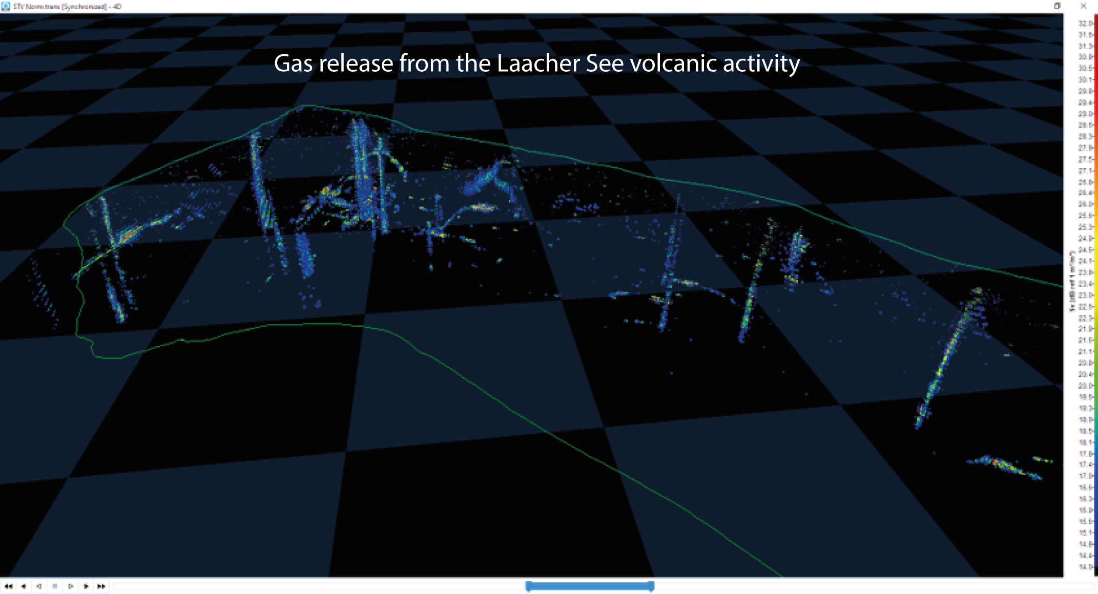
Gas detection and quantification using iXblue Echoes high-resolution sub-bottom profiler and Seapix 3D multibeam echosounder from the Laacher See (Eifel crater lake)
Wednesday 14th October - 09.00-11.00 | Papers session: "instrumentation, application to ocean observation"
Gases are most often driving volcanic eruptions. Contrary to atmosphere, CO2 bubbles are easily detected in water column using hydroacoustic methods. Two studies have monitored gas venting into Kelud Crater Lake (Indonesia) from a hydroacoustic station shortly before volcanic eruptions in 1990 and 2007. However, quantification remains complex due to 3D structure of clouds and acoustic interactions between bubbles. It is thus necessary to accurately map bubble clouds, to monitor their evolution and possibly to dissociate different gas origins to reduce volcanic risk. We present results from sedimentary deposits and water column gas distributions and quantification at the Laacher See (Eifel, Germany), using Echoes high-resolution SBP and iXblue Seapix 3D MBES, respectively. Backscatter profiles of elements in the water column allow to distinguish fish and gas bubbles and highlight several concentrated colocation of bubble plumes. Ongoing research on the Target Strength (TS) of bubbles suggest they are of small size (~35 µm), which would explain why, in the same spot, we did not observe gas bubbles using camera mounted on ROV. This raises new perspectives to improve CO2 budget modeling from volcanic bubbles release. Meanwhile, the Echoes 10 000 provide more than 40 m of penetration with an 8 cm-resolution, and reveal paleoenvironmental and paleoclimatic reconstruction perspectives, 3D modeling of remobilized materials and tephra deposits from volcanic activity, as well as gas diffusion through the sediment.
Gary Bagot, iXblue, France
Delph Subsea Positioning Software - iXblue’s innovative software solutions for subsea positionings
Thursday 15th October - 13.30-17.30 | Papers session MOQESM (session 2) - Robotics for marine observation
Improving operational efficiency is a recurring challenge for subsea operations. Throughout the life of a field, from construction up to decommissioning, several subsea vehicles will be deployed to cover various tasks such as pipeline and structure installation, maintenance or repair. An ROV or AUV assigned to a specific task will require multiple positioning sensors (LBL, USBL, INS…) to complete its mission. Defining the “good enough” subsea positioning strategy, i.e. to ensure a minimum accuracy without compromise on safety, can be a complex exercise. For instance, an overestimation of the LBL transponders required will directly induce vessel time and finally costly operations. On the other hand, a certain level of positioning redundancy may be requested for a vehicle operating close to a subsea asset in production.
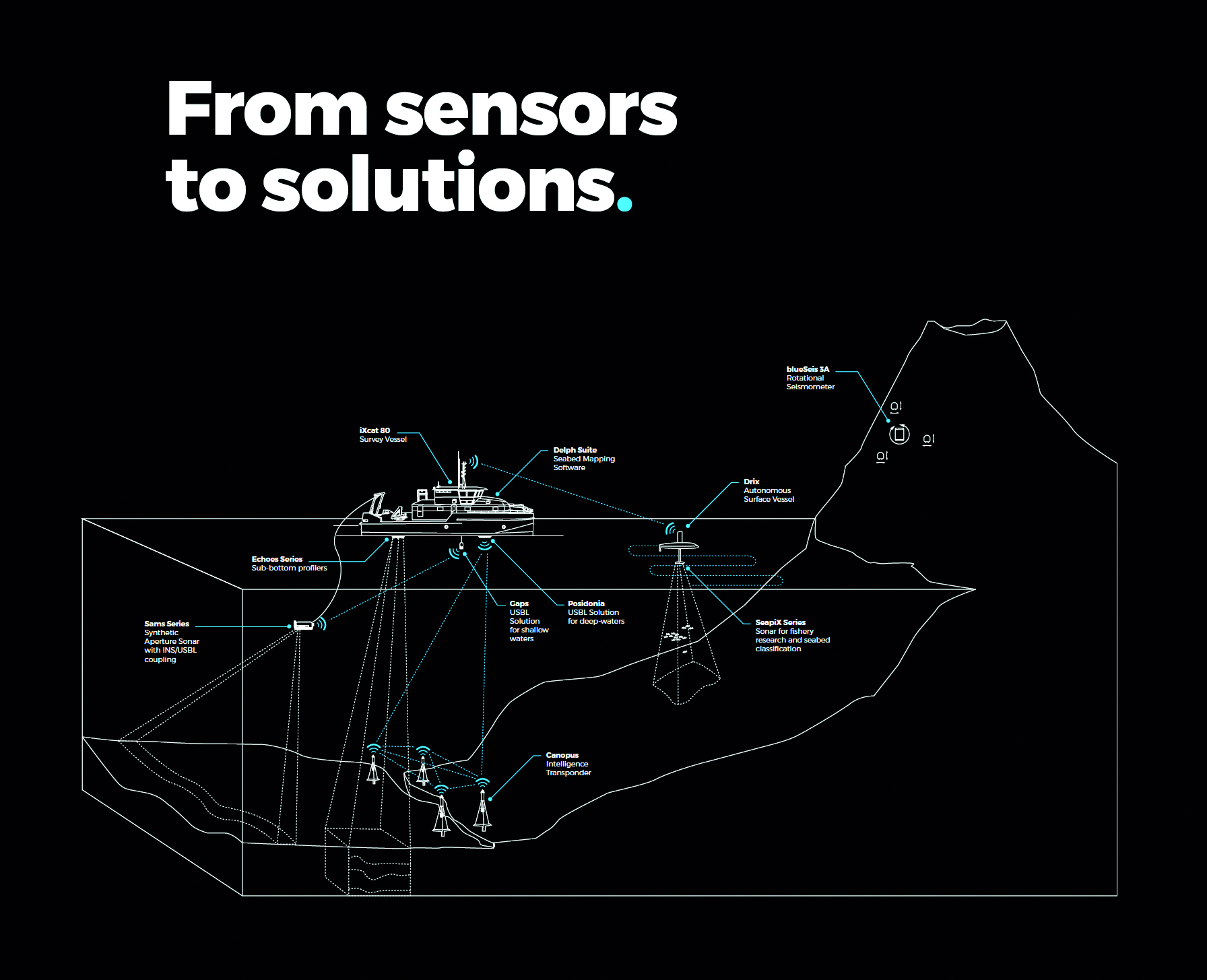
To ease the design and monitoring of a subsea vehicle navigation, iXblue has developed an integrated solution. Not only has the company broadened its product range with the new intelligent Canopus LBL Transponder and the new generation Ramses transceiver, but with Delph Subsea Positioning Software, iXblue now provides a complete integrated solution for subsea positioning that goes a step further by bringing significant efficiency. Divided in 4 modules (LBL Array Planning, Navigation Simulation, Operations, DelphINS) with an intuitive user interface, Delph Subsea Positioning (DSP) is an integrated software suite for the preparation, the operation and the post-processing of iXblue positioning devices (USBL, LBL and INS).
Nathalie Olivier, IxBlue, France
Test results before the deployment of a subsea geodetic monitoring system
Thursday 15th October - 13.30-17.30 | Papers session MOQESM (session 2) - Robotics for marine observation
Geodetic networks at sea are necessary to monitor active faults and the long term displacement of tectonic plates. iXblue has developed a new integrated subsea monitoring system: Canopus
The Canopus transponders are enable to regularly measure precisely the distance between the transponders that are in acoustic line of sight. The measurement are stored in a memory inside each beacon and can be collected from surface using acoustic modem. In collaboration with the IUEM, and in the framework of ERC Focus project, 8 Canopus beacons are going to be deployed at each side of the North Alfeo Fault in Sicilia for a 4 years monitoring program. To prepare the deployment, a first experiment took place in Brest Bay in July 2019. Thanks to Delph subsea positioning software, simulations enable to confirm acoustic line of sight between beacons considering the local bathymetry, the sound velocity profile and the height of the transponders above the seabed. We present here the test deployment and simulation results.
IN THE POSTER HALL
Lionel Fauré, iXblue Sonar Systems Division, France ; Didier Charlot, iXblue Sonar Systems Division, France ; Frédéric Mosca, iXblue Sonar Systems Division, France ; Mathieu Couade, iXblue Sonar Systems Division, France
iXblue ocean mapping from multibeam sonar synthetic aperture processing technique
For the last 10 years, iXblue develops an Inertial Navigation Multibeam Sonar system able to provide realtime
synthetic aperture georeferenced mapping. To meet the need of geological ocean floor mapping and deep-sea mining activity requirements, iXblue is able to image 1.8 km of swath at once with a 10cm definition map. This paper will present the evolution and benefits of iXsas processing and ultimate resolution vs swath coverage achieved by iXblue technology compared to classical side scan sonar. Inertial non Coherent integration and Coherent Processing allows different survey strategy and an optimisation of operation time.